
UN Backs Equal Earth Map to Correct Africa’s Size, US Opposes Resolution
 Mirian Gom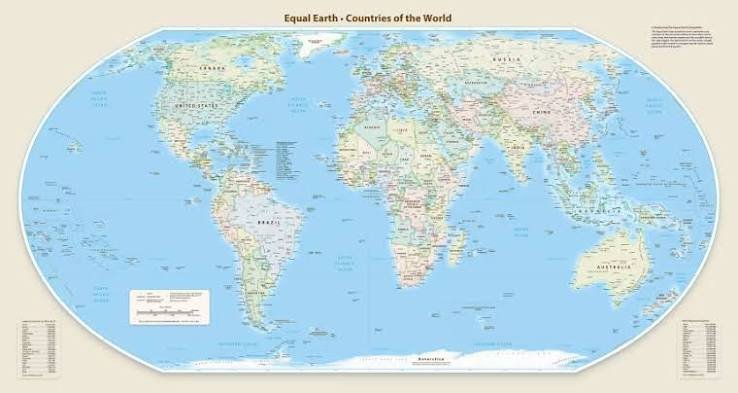
ABUJA, Nigeria – The United Nations General Assembly has voted overwhelmingly in favour of adopting the Equal Earth map projection, a move supporters say offers a more accurate representation of the world’s continents by correcting long-standing distortions that make Africa appear smaller than its actual size.
The resolution, championed by several African countries and supported by 164 member states, was adopted on Friday. The United States voted against the proposal, while six countries abstained.
Togo’s Minister of Foreign Affairs, Robert Dussey, who spearheaded the initiative, said maps shape public understanding and historical perceptions, making accurate representation important.
“Maps guide education, nourish the imagination and influence collective perceptions. When they present a distorted image of our planet, they risk perpetuating inaccurate representations across generations,” he said.
The Mercator projection was originally developed for maritime navigation because it preserves direction and angles, but its design enlarges land masses farther from the equator.
The Equal Earth projection, introduced by a team of cartographers in 2018, preserves the relative surface areas of continents while maintaining shapes that more closely resemble a globe.
One of its creators, Bojan Savric, previously explained that the projection accurately reflects the true size relationships between continents, making Africa, Latin America, South Asia and Oceania appear closer to their actual proportions.
French Foreign Minister Jean-Noel Barrot said the change corrects a visual imbalance that gives disproportionate prominence to countries such as the United States, Russia and China while diminishing Africa and other regions.
“Changing maps does not change the world, but correcting a distorted representation is an act of truth,” Barrot said.
The United States, however, criticised the resolution, arguing that the General Assembly should focus on more pressing global challenges.
About the Author


 Oluwatobi Adu
 Hope Ajayi