Korede Abdullah in Lagos
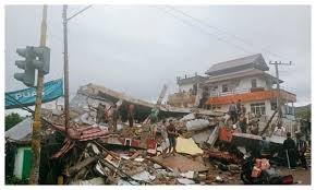
A powerful earthquake with a magnitude of 6.2 struck off the coast of Indonesia’s North Maluku on Wednesday.
According to the geophysics agency, the quake had a depth of 81 km (50 miles) and did not have the potential to trigger a tsunami. Fortunately, there were no immediate reports of damage or casualties.
Indonesia is located in a highly seismically active zone, known as the Pacific Ring of Fire, where different plates on the Earth’s crust meet and create a large number of earthquakes and volcanic activity.
This region is prone to powerful earthquakes and volcanic eruptions, making Indonesia one of the most disaster-prone countries in the world.
The country’s disaster mitigation agency has not yet commented on the incident, but the geophysics agency’s assessment suggests that the impact of the earthquake may be limited.
However, the incident serves as a reminder of the importance of disaster preparedness and mitigation measures in Indonesia, given its location in a high-risk seismic zone.